Bolivia - A Round Trip

If you followed my trip so far on this blog you read how I entered Bolivia via Oruro, then took the train to Tupiza and from there did an amazing tour across the Altiplano, ending in Uyuni. But what went on from there? Keep reading to find out about my round trip through Bolivia.
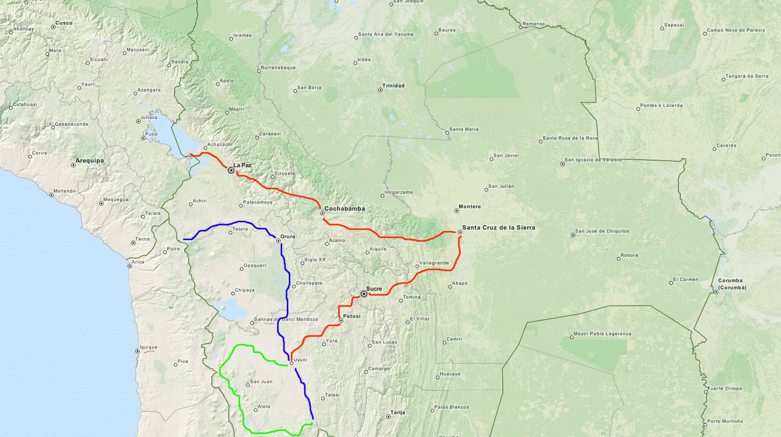
Read about the blue track here: San Pedro de Atacama to Tupiza - The Hard Way. The green track was covered here: Bolivian Altiplano Tour. The orange tracks starts in Uyuni, at the end of the tour through the Altiplano. I then continued to Potosí. Sucre was the next stop. After that I took a plane to Santa Cruz de la Sierra. From there I continued by bus to Samaipata. With another bus I went from Samaipata to Cochabamba. Another plane ride took me to La Paz. The final stage in Bolivia was by bus from La Paz to Copacabana. In the next paragraphs you will find some text to the stops and of course photos.
Potosí
Potosí is a lovely city and the capital of the Potosí Department. It lies at an approximate elevation of 4,000 meters, making it one of the highest cities in the world. Over Potosí thrones the mighty Cerro Rico (the rich mountain, called this, because of the vast richness of natural minerals, including silver). It is said that the Cerro Rico already shrunk by almost 300 meters because of the silver mine (one of the biggest in the world). The occurence of silver made it one of the wealthiest cities in the world during the New World Spanish Empire. The Spanish colonial mint (Casa de la Moneda de Bolivia) was located in Potosí for centuries, until the silver mines were depleted. I took a guided tour through the Casa de la Moneda and went on a tour through the silver mines (apparently workers are still working there). The visit of the mines was one of the most depressing experiences I had so far on this trip, the working conditions of the workers are simply terrible, this could fill up a whole blog entry itself.


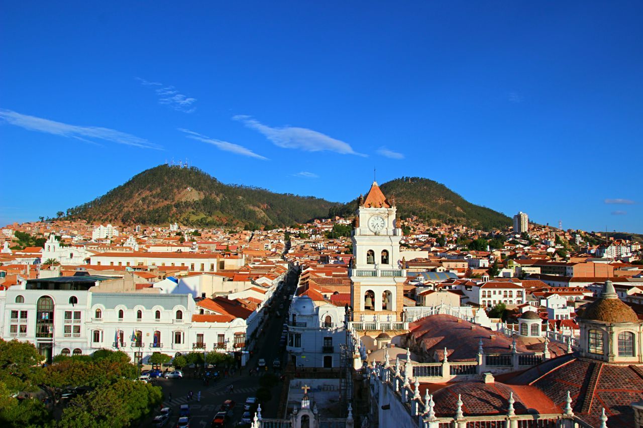
Sucre
The next stop was Sucre, the constitutional capital of Bolivia. It lies at an elevation of 2,810 meters, so the altitude sickness was slowing down and the temperatures were rising. The city is famous for its many white colonial buildings in the inner city center. It lies stunningly in midst of several mountains. Probably the highlight of every visit of Sucre is the visit of the The House of Freedom, where Simón Bolívar founded the republic of Bolivia (the nation is named after him in order to honor him). Other spots which are worthwile visiting are the General Cemetery and the Main Plaza.


Santa Cruz
Santa Cruz de la Sierra is the largest city by population in Bolivia (approximately 2 million people live in the metro region). Is also said to be the wealthiest. The city has a tropical climate, so the temperatures were around the 30°C mark, a welcome relief after the Altiplano. Somehow I carried a food poisoning from Sucre to Santa Cruz, which made my stay there not that pleasant as I wanted it to be.
Samaipata
Samaipata is a small town approximately 120 kilometers southwest of Santa Cruz in the foothills of the Andes. The main attractions (beside the very pleasant climate) are the archaeological site El Fuerte de Samaipata, a pre-Columbian site of a pre-Inca culture called the Chané, the nearby Amboro National Park and Vallegrande, the first burial site of Che Guevara. Other than that the surrounding mountains and nature are perfect for long-day hikes.


Cochabamba
Cochabamba is nicknamed "City of Eternal Spring", because of its spring-like temperatures year round. It's located in a valley in the Andes at an elevation of approximately 2,800 meters. The Main Plaza attracts lots of residents and tourists as well. Another attraction, shared both by residents and tourists, is a ride up the Cerro de San Pedro with the cable car to the statue of Jesus Christ, Cristo de la Concordia. From up the hill you can enjoy a beautiful panoramic view of the city.


La Paz
La Paz, seat of the Bolivian government, is located in a valley surrounded by mountains which merge into the Altiplano. The city itself stretches from 3,600 meters up to 4,000 meters above sea level, so welcome back altitude sickness! It is, de facto, the world's highest administrative capital, the official capital still being Sucre. I arrived at the El Alto International Airport, which is located, as the name suggests, in El Alto, the city next to La Paz on the Altiplano. Once I got off the plane I took a micro down to La Paz. The view you get when you cross the cliff of the Altiplano is amazing. La Paz sits in the valley and the thousands and thousands of houses nestle up the mountains and eventually spill over onto the Altiplano, to the never-ending city of El Alto. A truly fascinating experience. Once in La Paz you can enjoy amazing views at virtually every corner. I climbed a mirador called Kili Kili, rode one of the many cable cars (the whole system is called Mi Teleférico and consists of three lines, all built by the Austrian company Doppelmayr), did the world famous Death Road and explored the city by walking through the streets (which can be pretty exhausting at that height).


Copacabana
The last stop in Bolivia was the town of Copacabana, close to the border of Peru, situated at the shore of Lake Titicaca, at an elevation of 3,800 meters. It's a pleasant city with lots of tourism and the starting point for a visit of the Isla del Sol. Sadly my trip was dominated by constant rainfall so that I decided to continue quickly to Peru.


That's it, thirty days in Bolivia come to an end: I saw amazing landscapes, interesting cities, diverse climate regions and got a glimpse into the Bolivian culture. But everything has to come to an end. Off to the next stop: Peru!